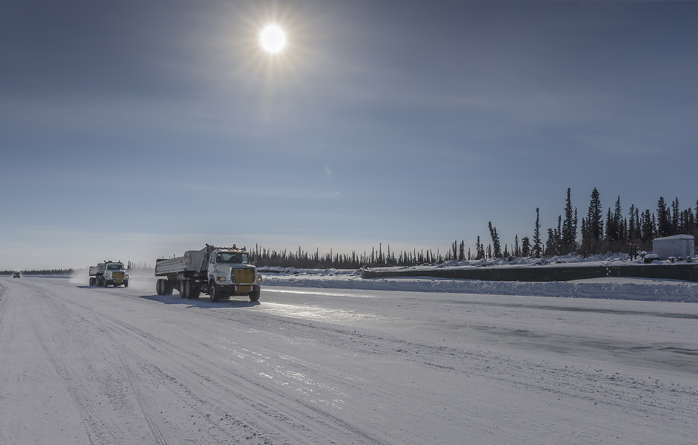
Tip of the Ice Road
As Arctic temperatures rise, Laurier’s Homa Kheyrollah Pour is partnering with northern Indigenous communities to ensure safe winter travel.
Chief Danny Gaudet has been building ice roads for more than 30 years. As a young boy, his mother and stepfather taught him their construction methods through storytelling.
“My mom said to me, ‘When you’re building ice roads, Danny, always pay attention because the ice could rip open at any second,’” says Gaudet, leader of Délı̨nę Got'ı̨nę Government. “There’s always a fear that I will go through the ice.”
Ice roads are essential to the people of Délı̨nę, Northwest Territories. Located 544 km northwest of Yellowknife, it is the only community on the shores of Great Bear Lake, the largest lake located entirely in Canada. Délı̨nę is home to less than 600 people, most of whom are Indigenous. There is no highway infrastructure that far north, so once the water freezes, hundreds of transport trucks travel over lake ice to restock the community’s supplies of food, fuel and household items.
“To cross the ice, you have to make sure that it’s strong enough to hold up to 60,000 kgs of weight,” says Gaudet. “People tell me the show Ice Road Truckers looks scary and I tell them, ‘The drivers are safe. We’re taking the risk because we’re the ones building the roads.’”
To mitigate that risk, Gaudet and his community members have been collaborating with Homa Kheyrollah Pour, the Canada Research Chair in Remote Sensing of Environmental Change at Wilfrid Laurier University. Since 2020, Kheyrollah Pour has flown to Délı̨nę each winter to work alongside Gaudet’s crew and introduce new technology that can make their work safer and more efficient.
Using ground-penetrating radar systems pulled by snowmobiles, along with drones and satellite observations, Kheyrollah Pour and her Laurier graduate students can measure the thickness of the ice on Great Bear Lake in real time. They can also detect where ice has cracked or buckled, which is instrumental in determining the best path for the ice road.
“I used to drill thousands of holes into the ice so I could develop a map manually,” says Gaudet. “Now Homa runs her machine over the ice and produces a map right away. We can have results in half an hour for a six-kilometre road, whereas if I had to drill it, it would take me two or three days.”
Through Kheyrollah Pour’s mentorship, local Délı̨nę road crews will soon be able to use the radar technology themselves. This knowledge is critical as climate change continues to make ice travel more precarious in northern communities. Northern Canada is warming three to four times faster than the global average and Gaudet is noticing the effects.
“We’ve been getting really heavy, wet snow pushing down on the ice in the middle of winter when it should be minus 40 degrees,” says Gaudet. “Homa and her Laurier research team are making our work more predictable, which I really appreciate.”
Kheyrollah Pour is learning just as much from the Délı̨nę community, gratefully absorbing their expansive knowledge of the lake and its ecosystem, and their deep respect for the land. Her learnings, combined with comprehensive data, contribute to the overarching goal of her research program: long-term safety and well-being for northern communities.
“[Homa] and her Laurier research team are making our work more predictable.”
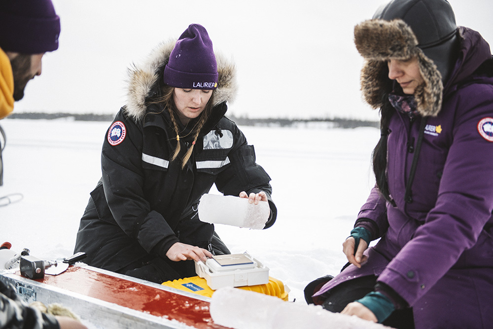 Kheyrollah Pour (right) and Laurier PhD students Arash Rafat and Alicia Pouw
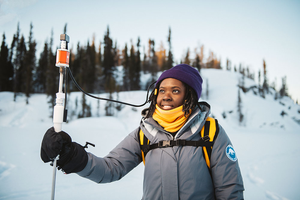 Laurier PhD candidate Gifty Attiah
Trained as a mathematician, Kheyrollah Pour has always felt exhilarated by solving difficult equations. She knew early in her academic journey that she wasn’t content to simply conduct science for the sake of science: she wanted to make an impact.
Kheyrollah Pour combined her love of math with her passion for water, and her focus gradually turned to cold regions hydrology during her graduate studies. Laurier was the perfect place to advance her career thanks to its longstanding research partnership with the Government of the Northwest Territories. Since becoming an assistant professor of Geography and Environmental Studies in 2019, Kheyrollah Pour has spent long stretches of time bundled up on the Arctic tundra studying snow and frozen lakes.
“We are developing mathematical and machine-learning models, as well as satellite observation algorithms, to monitor and understand the changes happening to northern lake ice, water quality and land cover,” says Kheyrollah Pour. “These changes are complex, which is why we employ multiple approaches and technologies. We are monitoring from the depths of lakes all the way up to the atmosphere so we can develop effective solutions and inform environmental policies in the face of climate change.”
Kheyrollah Pour leads the Remote Sensing of Environmental Change (ReSEC) research group, which includes nearly a dozen Laurier graduate students and staff members. They regularly accompany Kheyrollah Pour on her research trips to the Northwest Territories.
“Behind a computer, I make so many assumptions. But when I get out on the land, I see the hypotheses we’ve built in action and things make sense in a different way,” says Gifty Attiah, a PhD candidate in Geography whose research focuses on how ice thickness has changed over time. “Homa has taught me that if you’re passionate about what you do and make sure that your research is impacting people’s lives, then it’s worth doing.”
Kheyrollah Pour’s partnerships with Indigenous communities are rooted in the act of listening. She believes her role is to listen to each community’s needs and braid their traditional knowledge into scientific solutions together.
When Kheyrollah Pour was approached by members of Łutsël K'é Dene First Nation in 2022, their need was clear: safety. Unpredictable ice conditions had resulted in tragedy for the community of 300 people and residents needed a way to monitor ice thickness before travelling over frozen lakes.
“A couple of years ago, I lost my uncle when he went through the ice, along with his daughter and her boyfriend,” says Rubin Fatt, a local environmental Guardian. “He was my godfather. It really affected me because I spent a lot of time with him in the bush growing up and he taught me about the land. We learn from our Elders and pass it onto our young people.”
That responsibility guides Fatt in his role as Guardian within the Ni Hat’ni Dene network. “Ni Hat’ni Dene” means watchers of the land. He and his colleagues are stewards, conducting environmental monitoring and accompanying community members on their often-precarious snowmobile trips to traditional hunting grounds.
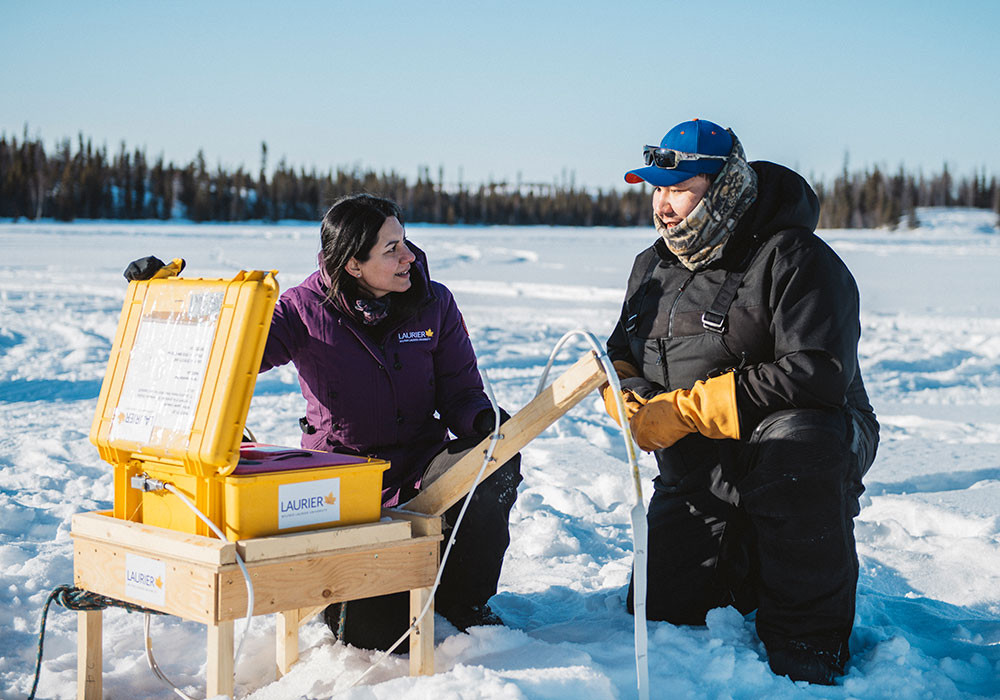
Hunting is vital for sustenance in Łutsël K'é, an isolated settlement along the eastern edge of Great Slave Lake, Northwest Territories. It is only accessible by air, boat or snowmobile. In January 2023, Kheyrollah Pour and her students travelled to Łutsël K'é and, alongside the Guardians, installed sensors in two locations on Great Slave Lake. The sensors collect ice thickness data every 15 minutes, letting the community know when it is safe to travel.
Kheyrollah Pour (right) with Guardians Rubin Fatt and Chase Lockhart
“The Guardians selected the locations based on safety concerns and we taught them how to install the sensors and collect measurements,” says Arash Rafat, a Laurier PhD student in the ReSEC research group. “We talked about the science behind the technology and paired it with what the Guardians already know about the ice and the land.”
Kheyrollah Pour says the first two years of the research partnership will involve continued training “side by side,” culminating in an independent local monitoring system.
“In a couple of years, the Guardians will be the ones telling us how safe the ice is,” she says.
After their first winter using the ice-monitoring sensors, Fatt and his colleagues already feel more secure in their ability to protect their friends and family.
“These sensors are really helping our community,” says Fatt. “It’s all connected to our phones, so we know when the ice is too thin. Now we know when to tell people not to travel.”
That’s exactly the kind of impact Kheyrollah Pour dreamed of making as a young mathematics student. Years later, she is as inspired as ever.
“Observing these magnificent ice roads melting away and the ice season getting shorter and shorter – it breaks my heart,” she says. “But it also fuels my determination to work together with northern communities, ensuring that they can preserve their traditional ways of living through adaptation and innovative solutions.”
“We are observing what happens from the bottom of the lake all the way up to the atmosphere so we can find solutions and inform environmental policy in the face of climate change.”
Join Laurier and our collaborators as we build a stronger, sustainable future for Northern Canada and our planet.